Course Number
Geog 603
SFSU Bulletin Description
Credits
3
Course Type
College
Department
Course Description
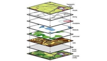
This course is an introduction to computer-based geographic analysis and problem-solving. It covers the fundamentals of Geographical Information Systems (GIS) technology and how it is being applied in various disciplines. Students will learn how to collect, organize, analyze, and display geographic data. Each student will complete a series of lab exercises that exemplify the typical steps in a GIS project. The course will culminate with students carrying out their own GIS project. Esri ArcGIS software will be used for the laboratory portion of the course.
Term