Hillslope gully photogeomorphology using structure-from-motion
Christian* P, Davis JD (2016). Hillslope gully photogeomorphology using structure-from-motion. Zeitschrift für Geomorphologie 60 (2016), Suppl. 3, 059–078. Online: DOI: 10.1127/zfg_suppl/2016/00238.
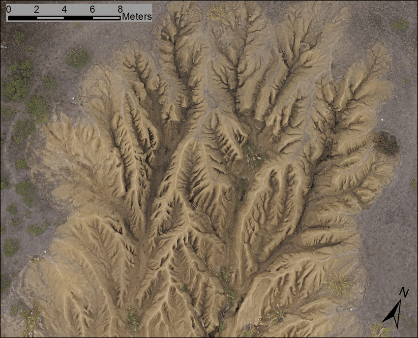
Study of hillslope gully processes and erosion rates requires fine resolution elevation data that may not be achievable using available public data or topographic survey methods; low-altitude remote sensing methods may be the most suitable method. The goal of this research is to identify a low-cost, low-altitude (< 100 m) solution that provides elevation data of an accuracy needed for geomorphological research on steep hillslope gullies. For this application, a multi-rotor unmanned aerial system (UAS) was identified as uniquely capable of providing accurate results in a challenging field setting. Key characteristics include portability, the ability to operate without runways in rugged terrain, and the ability to hover allowing for observations that require loitering. A consumer-grade hexacopter from 3D Robotics providing a platform for a Canon CCD-based point and shoot camera (Powershot S95) with a mass of 195 g was identified as suitable for the low-cost configuration. An especially challenging gully was chosen, developed on a 36 % slope on a coastal terrace in San Mateo County, California, with up to vertical sidewalls and internal channel and interfluve complexity. The gully is 6 m deep in cross section, 50 m long and has a 20 m maximum width. For this site, internal channel features are not observable from stable sites suitable for total station or terrestrial laser scanning survey, and a tethered (kite) solution proved unworkable, thus the unique perspective of a low altitude vertical perspective of the UAV provided the best solution. Twenty two ground control points were established using a 3-second Leica total station. Three flights, at 10 m, 20 m, and 70 m above the head of the gully, each provided suitably accurate results using a structure-from-motion (SfM) approach, with cross-validation root-mean-squared-errors (RMSE) of 0.0566, 0.0836, and 0.0904 m, respectively; but when all photographs were used cross-validation RMSE was 0.1290 m. Orthophotography created by the SfM software, Agisoft Photoscan, achieved resolutions of 0.75, 1.0 and 2.5 cm ground surface distance, respectively, with digital surface models at twice those values: 1.5, 2.0 and 5 cm, respectively. These resolutions can provide a precision for volumetric estimates substantially better than available public data, such as the finest USGS National Elevation Dataset resolution of 3 m, or conventional aerial LiDAR. The ability to easily and cheaply repeat surveys and the fine resolution will make it possible to study erosion rates and estimate sediment yield through change in volume, and can also be used to assess causes and processes related to piping systems from rodents, as piping inlets are observable in both orthophotography and digital surface models.