Geomorphic Change Detection in an Incised Montane Meadow Stream Channel
Abstract
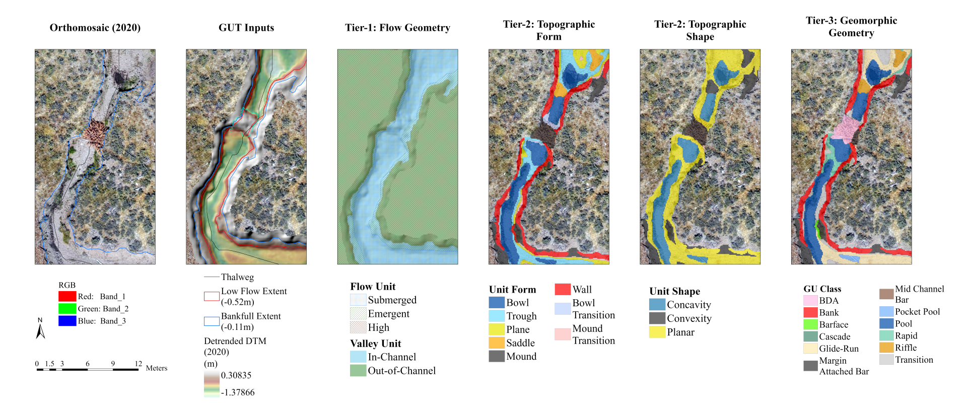
Sierran montane meadows are dynamic wetland systems that provide important ecosystem functions and services but have been affected by extensive land-use and widespread degradation often resulting in stream channel incision. To restore meadow hydrogeomorphic functions, various process-based strategies are increasingly applied, such as beaver dam analogs (BDAs) and other biotic mechanisms, which seek to accelerate incision-aggradation cycles and floodplain re-connectivity in incised channels. High-resolution topographic (HRT) survey methods are typically needed to map stream channel characteristics (e.g., geometries, geomorphic units) and to monitor stream adjustments at the scales which erosion and deposition processes tend to occur. Once acquired, Geomorphic Change Detection (GCD) techniques are needed that can detect elevation surface changes between repeat topographic surveys while accounting for model ‘noise’ and surface representation errors.
In this project, structure-from-motion (SfM) photogrammetric techniques are used to acquire dense point clouds, DEMs (0.1 m2), and orthophotos (0.01 m2) from repeat Unpiloted Aerial Systems (UAS) based aerial imagery (2019, 2020, 2021) of an incised subchannel in Red Clover Valley, a montane meadow located in the northern Sierra Nevada in Plumas County. DEMs of Difference (DoD) are used to detect and characterize geomorphic changes for a ~0.26km section of the study reach for two survey periods, 2019-2020 (DoD-1) and 2020-2021 (DoD-2), with decimeter scale resolutions and precisions. GCD methods, such as DEM differencing, probabilistic thresholding of the raw DoDs based on uniform and spatially variable DEM error models, and DoD budget segregation based on a classified Geomorphic Unit (GU) mask (e.g., bank, bed, bar, pool units) are used to support geomorphic interpretation. The analysis results capture various geomorphic change ‘signals’ as well as extensive model ‘noise’ associated with positional (xyz) uncertainties, surface versus ground misclassifications, and grid-based surface representation errors.
The clearest elevation changes (95% CL) were observed for cutbank erosion and BDA installation with large change magnitudes (e.g., > ±0.27m) visible in the (~1cm) 2019-2020 orthomosaics. Although bed, bar, and pool erosion signals (m3) were also detected in DoD-1 these were largely obscured by surface water or georeferencing errors or were difficult to validate without additional field measurements due to their relatively low change magnitudes (e.g., < ±0.2m). A roughly unchanged ‘dry’ condition was also observed for DoD-2 (2020-2021) that highlighted different sources of positional and surface representation errors (e.g., vegetation and bank shadows) present in the SfM-reconstructed DEMs. Between the DoDs, the spatial effects of the uniform error threshold (e.g., ±0.18) and the spatially variable (FIS) error threshold on DoD change detections are investigated and compared to discuss the merits and limits of each approach in this case. Sources of uncertainty in the SfM-based DEMs (e.g., positional, classification, surface representation) are also identified and discussed with some recommendations for improving SfM data reconstructions and precisions, as well as suggestions for future SfM-based GCD research in incised montane meadow streams.