Remote Sensing: Classifying Urban Land Use Types with Satellite Imagery
Abstract
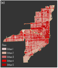
An accelerating trend of global urbanization and subsequent environmental impacts makes frequently updated land use and land cover (LULC) maps critical. LULC maps have been widely created through classification of remotely sensed imagery. Maps of urban areas have been both dichotomous (urban or non-urban) and entailing of discrete urban types. This study incorporated multispectral built-up indices designed to enhance satellite imagery to develop new urban classification schemes. The indices examined are the New Built-up Index (NBI), the Built-up Area Extraction Index (BAEI), and the Normalized Difference Concrete Condition Index (NDCCI). Landsat Level-2 data covering the city of Miami, FL, USA was leveraged with geographic data from the Florida Geospatial Data Library and Florida Department of Environmental Protection to develop and validate new methods of supervised and unsupervised classification of urban area. NBI was found to be useful for classifying urban features through object-oriented image analysis. BAEI was utilized to visualize and track urban development as a low-high gradient. NDCCI was composited with NBI and BAEI as the basis for a robust urban intensity classification scheme superior to that of the urban intensities featured in the 2016 USGS National Land Cover Database. BAEI, implemented as a shadow index, was incorporated in a novel infill geosimulation of high-rise construction. The findings suggest that the proposed classification schemes are advantageous to the process of creating more detailed LULC maps in response to the rising global demand for them.